The global ocean covers 71% of the planet. Across these vast spaces, interactions between the ocean and atmosphere are primary drivers of Earth’s weather, climate and marine productivity.
Satellites, instrumented moorings, and infrequent ship-borne research missions have revealed much about these interactions, but large areas of the ocean are significantly undersampled.
To fill in the gaps, scientists have increasingly turned to an array of Uncrewed Surface Vehicles (USV), some of which can navigate tens of thousands of kilometres to capture key observations autonomously. Most rely upon renewable energy from wind, waves, and the Sun for propulsion and to power their sensors and telemetry systems.
“This technology is currently booming,,” said Ruth Patterson, an oceanographer with Charles Darwin University in Australia. “We urgently need to establish a global network to agree on standards and best practices so that USV data can be used to enhance our understanding of the oceans and climate.”
To rectify that, Patterson and an international team of researchers including scientists from NOAA’s Pacific Marine Environmental Laboratory (PMEL), the University of Washington, and the Cooperative Institute for Climate, Ocean, and Ecosystem Studies (CICOES), conducted a review of the global use of USVs and how well the recommended attributes of a global observing network are met.
The Observations Coordination Group (OCG), which oversees the Global Ocean Observing System (GOOS), has identified ten important attributes of an in-situ GOOS network, about half of which were well-met or progressing. In particular, the review cited 200 USV datasets, published in 96 peer reviewed studies, capturing observations of 33 physical, biogeochemical, biological and ecological processes spanning the air-sea transition zone across the global ocean.
“An endorsed USV GOOS network needs to have or be working towards a data management infrastructure that includes defined standards and recommended practices,” said Kevin O’Brien, a CICOES scientist and vice chair of the OCG. “This is the next step for an emerging network of GOOS.”
The review was carried out under the auspices of the Observing Air-Sea Interactions Strategy (OASIS), a program of the United Nations Decade of Ocean Sciences for Sustainable Development, and was published in the journal Frontiers of Marine Science.
Patterson will present a proposal to establish a permanent global USV network within the Global Ocean Observing System to the Observations Coordination Group during its April meeting in France.
PMEL scientist Meghan Cronin, co-chair of the OASIS program, said “this offers a roadmap for building this international network that offers a key to new frontiers in ocean sciences.”
Watch CICOES Director John Horne on the International Council for the Exploration of the Sea’s web series Hidden Gems. He discusses a solar-powered acoustic monitoring system that delivers near-real-time data to support sustainable fishing.
Tsunamis pose a serious threat to U.S. coastal communities, but decades of research and innovation are turning the tide on preparedness. At CICOES, scientists are partnering with NOAA to advance tsunami detection, forecasting, and hazard assessment. CICOES and NOAA research is helping protect lives, safeguard critical infrastructure, and strengthen coastal economies.
The History and Future of Tsunami Research at CICOES in Partnership with NOAA
On December 26, 2004, a massive undersea earthquake off the coast of Sumatra triggered a catastrophic tsunami that devastated communities across 14 countries, killing more than 230,000 people and displacing over 1.7 million. It was one of the deadliest natural disasters in recorded history—and a wake-up call for governments around the world. In its aftermath, NOAA accelerated efforts to strengthen America’s tsunami preparedness, deploying a network of Deep-ocean Assessment and Reporting of Tsunamis (DART) buoys across the globe. This state-of-the-art warning system dramatically improved global tsunami detection and forecasting—and CICOES scientists have been a critical partner every step of the way.
The 2011 Japanese tsunami caused immense devastation. (Photo credit: The Brookings Institute)
The effectiveness of DART was on full display in 2011 when a severe tsunami struck Japan following a magnitude 9.0 earthquake. While the initial estimates based on seismic data dramatically underestimated the earthquake’s size and tsunami risk, the DART system, informed by real-time sea level data, told a different story. Thanks to the integration of DART data and advanced forecast models, NOAA’s Tsunami Warning Centers issued accurate forecasts for U.S. coastlines, giving Hawaii six hours of critical warning time for evacuations. CICOES researchers helped to refine these forecasts with high-resolution modeling and inundation predictions, demonstrating the essential role of basic and applied science in life-saving operations.
The 2011 Japanese tsunami resulted in destabilizing damage to the Fukushima Daiichi Nuclear Power Plant. In recognition of similar vulnerabilities in the U.S., this also marked the start of CICOES’ collaboration with the Nuclear Regulatory Commission. Scientists conducted comprehensive tsunami hazard assessments for nuclear facilities on both the U.S. east and west coasts, illustrating how CICOES expertise informs national safety standards far beyond traditional tsunami zones.
At the heart of NOAA’s modern tsunami warning system is the DART network and the Short-term Inundation Forecasting for Tsunamis (SIFT) system. Hand in hand with NOAA, CICOES scientists have played a key role in siting DART buoys, ensuring optimal placement for sensitivity and cost efficiency. They also developed SIFT, the real-time flooding forecast system that combines seismic and DART data with NOAA’s Method of Splitting Tsunami (MOST) model to provide accurate, community-level tsunami inundation predictions for more than 70 U.S. ports and coastal communities. As the only forecast system to pass NOAA’s rigorous operational testing, SIFT has become an international standard—now utilized by U.S. allies like New Zealand and Chile.
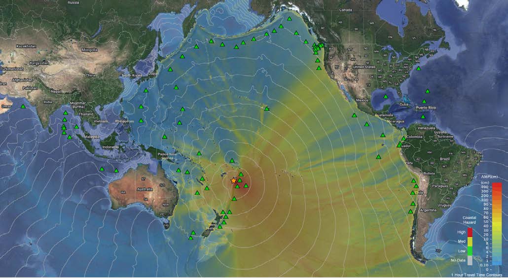
The 2022 Tonga volcano eruption and tsunami. Green triangles represent the international network of DART stations.
The reliability of the DART buoys and SIFT model was tested again in 2022, when the eruption of the Hunga Tonga-Hunga Ha’apai volcano triggered a tsunami that impacted oceans around the globe. Unlike earthquake-based events, this non-seismic source challenged traditional warning methods. Once again, the NOAA and CICOES systems provided the most reliable data, giving accurate tsunami threat estimates for coastlines across North and South America. These tools measure how water is actually moving—providing real-time observations that seismic data alone can’t match.Looking ahead, CICOES scientists are spearheading the development of the Common Analytic System (CAS), the next generation of tsunami forecasting technology. CAS aims to unify disparate systems and provide more accurate and faster forecasts of tsunami hazards, including near-field events that offer little warning time. This ambitious project is at a critical juncture. Continued federal funding is essential to ensure its success and maintain the United States’ leadership in tsunami preparedness.
CICOES’ contributions don’t stop at forecasting. Their research has shaped international building codes, including provisions adopted by the American Society of Civil Engineers (ASCE) to protect coastal infrastructure in tsunami-prone zones. And, in partnership with the U.S. Department of State, CICOES experts have conducted tsunami risk assessments for over a dozen U.S. embassy sites worldwide, helping ensure they meet stringent safety standards.
Ongoing CICOES research is further enhancing tsunami models by incorporating debris and sediment transport, improving the accuracy of inundation forecasts. CICOES scientists are also working to integrate artificial intelligence and high-performance computing to deliver faster, more sophisticated warning systems.
To see an example of CICOES tsunami modeling, watch this 90 second simulation of how a magnitude 9.1 earthquake in the Cascadia Subduction Zone would affect the community of Newport, Oregon. This simulation also models how coastal debris (such as shipping containers) would respond.
CICOES is uniquely positioned to deliver advances in tsunami research, bridging the gap between the science and NOAA’s operational tsunami warning mission. CICOES and NOAA researchers not only save lives but also protect American communities and industries from costly false alarms and unnecessary evacuations. With continued investment, CICOES and NOAA will keep the U.S. at the forefront of tsunami readiness—turning cutting-edge science into actionable solutions.
Saving Lives—and Livelihoods
Accurate tsunami forecasting doesn’t just save lives—it protects economies. Improved forecasts reduce unnecessary evacuations and prevent costly shutdowns of ports, industries, and infrastructure. For example, a false tsunami alert in Hawai‘i in 1986 cost an estimated $112 million in inflation-adjusted dollars.
Today, advanced tools like DART and SIFT help avoid such losses, safeguarding coastal communities and their economies. In fact, the cost of a single averted false alert can more than offset the nation’s investment in basic and applied tsunami research.
A Deeper Dive: The Systems and Technology
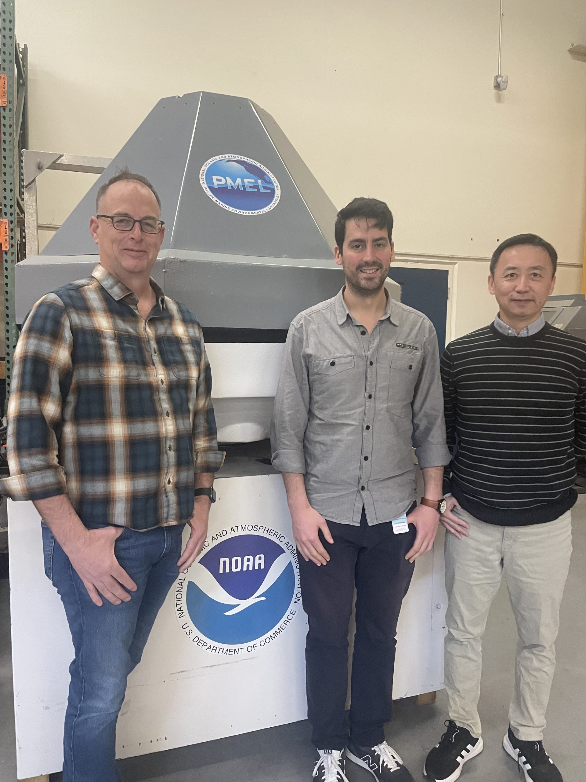
From left to right, CICOES tsunami researchers Clint Pells, Ernesto Guerrero-Fernandez, and Yong Wei pose with a DART buoy.
DART Buoys: The Front Line of Defense
Deep-ocean Assessment and Reporting of Tsunamis (DART) buoys provide real-time data on tsunami waves as they travel across the ocean. Developed by NOAA with support from CICOES scientists, these buoys are critical for accurate, early warnings—giving coastal residents valuable time to prepare, evacuate, and save lives. There are currently 74 DART buoys in operation around the globe, casting a wide net of protection around U.S. communities and interests.
Each DART consists of two main components:
A bottom pressure recorder (BPR) placed on the seafloor, which is comprised of a sensor that closely monitors water pressure and a transmitter that communicates these readings to the surface, among other elements;
And a surface buoy, which contains a variety of electronics to receive data from the BPR and transmit it to the wider network of tsunami warning systems.
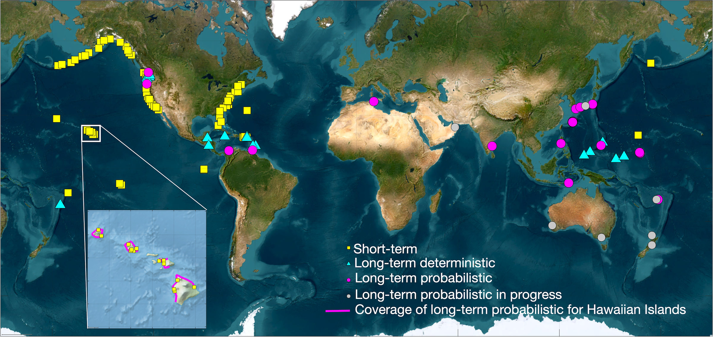
Short and Long-Term Tsunami Hazard Assessment
Developed by CICOES and NOAA’s Pacific Marine Environmental Laboratory, the Short-term Inundation Forecasting for Tsunamis (SIFT) system combines seismic and DART data to provide real-time, community-level inundation predictions for more than 70 U.S. ports and coastal communities.
CICOES also plays a key role in developing long-term tsunami hazard models that inform coastal planning and infrastructure. Through probabilistic tsunami hazard assessments (PTHAs) and other long-term models, CICOES helps identify at-risk areas and supports the development of building codes, evacuation routes, and community preparedness plans. For example, CICOES scientists have partnered with the Nuclear Regulatory Commission to assess the impacts on nuclear sites, the Department of State to assess impacts on embasy sites, and the American Society of Civil Engineers to advise on updated building codes.
Select Publications
The following articles from CICOES and PMEL scientists offer a more in-depth look at the tsunami research that has led—and continues to lead—to safer coastlines in the United States and around the globe.
Fernandez, E.G., M.J.C. Diaz, Y. Wei, and C. Moore (2024): Modeling sediment movement in the shallow-water framework: a morpho-hydrodynamic approach with numerical simulations and experimental validation, Ocean Modeling, 192, 102445, https://doi.org/10.1016/j.ocemod.2024.102445
Wei, Y. (2024): Global tsunami hazards and risks, Chapter 13 of “Probabilistic Tsunami Hazards and Risk Analysis Towards Disaster Reduction and Resilience”, Ed. Goda, K., Risi R., Gusman, A. and Nistor, I., 1st Edition, Oct. 18, 2024. Paperback ISBN: 9780443189876. eBook ISBN: 9780443189883