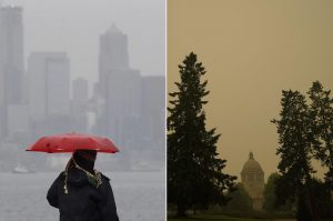
What WA’s Cold, Wet Spring Means for Summer Wildfires
Some think the rainy season’s silver lining is a decreased risk of wildfires later in the year. That may not be the case.
By Hannah Weinberger, Crosscut

Spring 2022 was cold and wet even by Washington state standards. While some residents complain about winter overstaying its welcome, others may be cautiously optimistic about avoiding deadly heat waves and what a damp spring and good levels of snowpack in May could do for our summer wildfire outlook.
Matthew Dehr, a fire meteorologist with the Washington State Department of Natural Resources (DNR), says he’s confident we’ll see a less-intense fire season on the west side of the state this summer. “But I don’t know if I’m willing to say that for the east side,” he says.
That’s because rain doesn’t eliminate the risk of wildfires. In some places, spring rains are actually likely to worsen fire risk later in the season. And a lot of that comes down to what happens when you get April showers: May flowers — or in Washington’s case, lots of grass.
Why it’s been a (mostly) calm fire season so far
Rain reduced early-season fire risk, experts say. There are no state-level burn bans across Washington state as of June 23. On DNR land — 5.6 million of the state’s 45.6 million acres — 95 fires have burned 86 acres so far this year as of June 24, compared to 549 fires burning 1,584 acres over the same period last year.
That’s because rain increases soil moisture, which helps tamp down drought levels and also cools the air, keeping temperatures lower. In turn, that prevents live trees and plants from drying out and becoming easy fuel.
This notably wet season can be credited to unusual activity in the La Niña climate pattern, in which strong winds blow warm Pacific Ocean waters westward over many weeks or months, creating a cool, wet winter climate for the Pacific Northwest. But this year, La Niña strengthened through May, something Dehr says has only happened twice since 1950.
The Climate Prediction Center of the National Weather Service forecasts the pattern might continue through the fall and winter, Dehr notes, quickening the end of fire season. Washington’s assistant state climatologist Karin Bumbaco says La Niña isn’t typically a player in our summertime weather.
Ultimately, summer weather and how we interact with nature matter much more than any spring climate conditions could, Dehr says. And climate patterns like La Niña might set the stage for fire risk, but extreme weather events that happen on a much shorter time scale are what drive a critical fire weather day, Dehr says. In the likely event of a more short stretches of hot, dry days like this past weekend, that wet, cold spring could really get us into trouble in Eastern Washington. Much of Eastern Washington is at risk of drought, and some of it already is experiencing one. The Climate Prediction Center currently predicts above-normal temperatures and below-normal precipitation in Eastern Washington July through September.
Luckily, weather forecasting technology prevents these events from blindsiding us. Meteorologists are able to forecast up to 10 days into the future. However, John Saltenberger, fire weather program manager with the Northwest Interagency Coordination Center, says they are less confident in forecasts more than five days out. The National Weather Service’s Storm Prediction Center issues critical fire weather outlooks, or forecasts, up to eight days out, but often leaves blank the last six of those days, he says. Early warnings about dangerous conditions can help firefighters organize in time to stop fires in their tracks or catch them quickly.
More than that, rains create conditions that help fires spread more quickly as soon as that hot, dry weather comes.
